
page updated
15 October 2010
Carrickfergus Harbour Branch
Little is now visible of this line but the accessible remains were walked on 26 September 2010. Position names in the text match those used in the Google Earth file that is available. Coordinates in the text were recorded using a Garmin Colorado 300 unit. Garmin's Map Source application gives five figures of decimal rather than the six figures declared by Google Earth.
Historical Information & Timeline
This list is a collation of information published variously by Ralph Rawlinson (Bygone Lines Yahoo Group and others), in the Carrickfergus & District Historical Journal (volume 8 of 1995), and Stephen Johnson's Atlas & Gazeteer of the Railways of Ireland (published 1997).
| Date | Event |
|---|---|
| 12 April 1848 | Belfast and Ballymena Railway opened a single track branch from Carrickfergus Junction (Greenisland, 6m56c) to Carrickfergus. Initial service of five passenger trains each way each day but no goods trains. |
| 15 May 1860 | Belfast & Ballymena Railway renamed Belfast and Northern Counties Railway. |
| 1860 | Original Carrickfergus station replaced by a 'permanent' one. Station lost its alcohol licence at the same time. |
| 1 October 1862 | Carrickfergus and Larne Railway opened from Carrickfergus Harbour Junction (9m10c) to Larne Harbour. 1860 Carrickfergus station closed and replaced by a new one. |
| September 1863 | Carrickfergus Junction to Carrickfergus Junction doubled. |
| 1 January 1887 | Carrickfergus Harbour Junction Railway opened from Carrickfergus Harbour Branch Junction (9m10c). Branch quoted as 1 mile, 6 furlongs, 15 chains and 23 yards in length to the new West Pier, plus a further 2 furlongs 17 yards to the East Pier. Carrickfergus Harbour Junction Railway shown in street and town directories (1910) as managed by the Urban District Council. |
| 1 January 1890 | Carrickfergus and Larne Railway amalgamated with the Belfast and Northern Counties Railway. |
| 1895 | Present day Carrickfergus Station (9m45c) opened as replacement for the 1862 station which had burnt down. |
| 1902 | 25" OS Map published describing the line as a Mineral Railway (i.e. one not carrying passenger traffic). |
| 1 July 1903 | Belfast and Northern Counties Railway sold to Midland Railway and operated under the title of Midland Railway (Northern Counties Committee). |
| 1 January 1923 | Midland Railway absorbed by the London Midland and Scottish Railway as a result of the Railways Act, 1921. |
| 1 January 1948 | Northern Counties Committee placed under control of the Railway Executive of the British Transport Commission but not nationalised. |
| 1948 | Carrickfergus Harbour Junction signal box replaced to facilitate connections with Courtauld's railway. |
| 1 April 1949 | Northern Counties Committee nationalised and absorbed as part of the Ulster Transport Authority. |
| 1957 | Line closed. |
| ?? | Carrickfergus Junction station renamed Greenisland. |
Carrickfergus has had a total of four different railway stations, on two different sites, which carried the name Carrickfergus. Other stations within the vicinity were Mount (Courtauld's Platform) (8m60c), Clipperstown (9m20c), Barn (10m03c), Downshire (10m38c) and Eden (11m03c).
Carrickfergus Harbour Junction
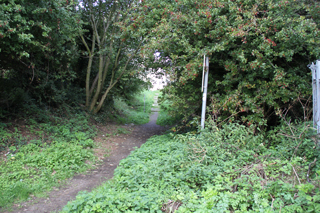
This Junction was close by the 9 mile post (counted from Belfast York Road), just to the east of the crossing of the Woodburn River. The junction site is no longer visible from the Harbour Branch as the still extant railway is hidden behind the trees and houses of present day Minorca Drive.
The pictures were taken at Photo Position 22 (coordinates N54.71749 W5.82361) at the cul-de-sac end of Minorca Drive
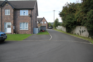
Looking towards Belfast.
The 'Larne Line' is hidden by the fence
and trees on the right hand side of the picture.
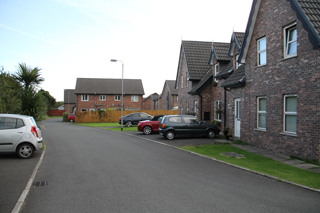
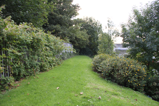
Looking towards the Harbour.
The line of route curved through the
houses on the right.
The signal box at Carrickfergus Harbour Junction still survives. I have included it on the Larne Line page.
The section from here to Windmill Hill was completely lost with the building of the Minorca Drive housing estate.
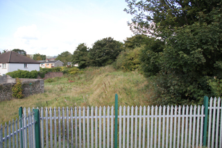
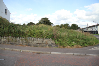
Windmill Hill
The line arrives here on a rising gradient and flattens out to a wider area. The site presumably had a windmill on it before the railway came. Photo Position 21 is at the northern end of the wide section and may well mark the station throat or the Minorca Sidings.
Looking towards Belfast.
Houses now occupy the line of the railway.
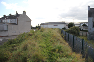
Looking towards the Harbour.
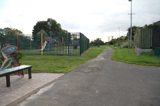
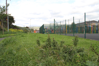
Site occupied by children's playground,
part inside and some outside stockade.
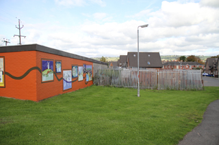
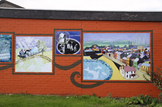
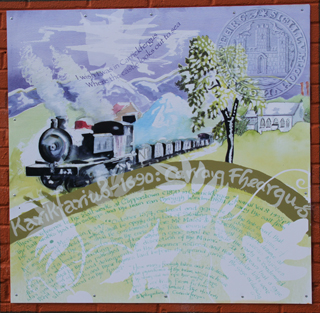
Someone with a sense of history has adorned the building with a mural commemorating past activities. These include the windmill, the salt works and the railway. It is said that the salt works here produced table salt.
.
.
The text above the train on the railway panel reads: “I wish I was in Carrickfergus, Where the castle looks out to sea”.
The lower part , below the heading “Karikfarius-1690 : Carraig Fheargus” starts: “There is reference to the Salt works at Clipperstown c1870 in Carrickfergus Journal Volume 8 1995 p31. The Salt works had own sidings and the train ran through Windmill Hill to carry the salt from the mine.”.
The remaining text is not relevant to the railway. Salt mining (for rock salt) still continues at Kilroot. The article in the Journal is the one mentioned at the top of this page concerning the railways of Carrickfergus.
Windmill Hill
Moving to the southern end of the wide area Photo Position 20 we can see just how large the children's play area is.
Looking towards Belfast.
The playground is prominent.
Looking towards the Harbour.
From here the railway route starts its descent to the Harbour.
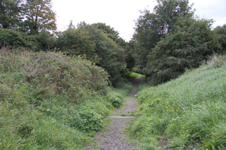
Photo Position 19
There was clearly some sort of bridge here where the railway crossed over an east-west right of way. It is to the right (in the left hand picture).
Looking towards Belfast.
Probably the best kept section of
the surviving alignment.
The route beyond here to Irish Quarter is securely fenced and appears to be a 'no mans land', possibly owned by Translink as successor to the previous railway companies.
Irish Quarter
The 1902 25" OS map shows no evidence of any path or other right of way at this point. But, as is evident today in Photo Position 18 one now exists and the railway embankment has been breached behind the fence in the left hand picture.
Looking towards Belfast.
Looking towards the Harbour.
Tramway Bridge
The two-arch limestone bridge that crossed Irish Quarter South at Photo Position 17 is no more. It was quite low and double deck buses (and juggernauts) could not pass. After demolition a new part of Shore Road was constructed allowing through traffic to avoid the centre of Carrickfergus which became quieter. The new road also divorced the Castle from the town centre!
Looking towards Belfast.
Looking towards the Harbour.
Beyond here the railway line has completely disappeared and the land beyond the Shore Road has changed beyond recognition.
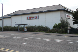
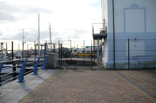
Harbour Approach
Looking towards Belfast.
The railway went from my position
and passed through the corner of Sainsburys.
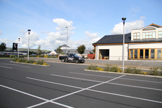
Looking towards Belfast.
The railway went through the pick-up truck
passed to the left of the building.
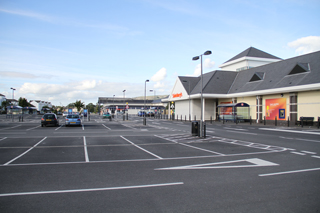
Quayside Photo Position 13
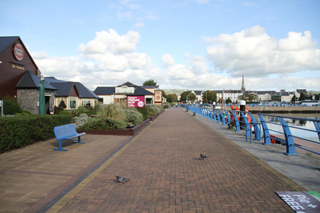
Very different from the days
of the railway.
Looking towards the Harbour entrance.
Beyond here is now the private domain
of Carrickfergus Boat Club